The state hasn?t been hit by such a storm since 1858 ? but the chances rise in El Nio years like this one
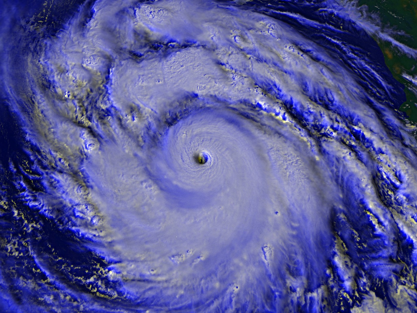 Hurricane Linda, a Category 5 monster in the Pacific Ocean in 1997, briefly looked like it might head toward Southern California. Image: NASA/Goddard Space Flight Center Scientific Visualization Studio
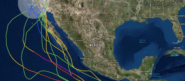
 All of the tropical storm systems that passed within 200 miles of a point mid-way between San Diego and Los Angeles from 1950 to 2017. Source: NOAA
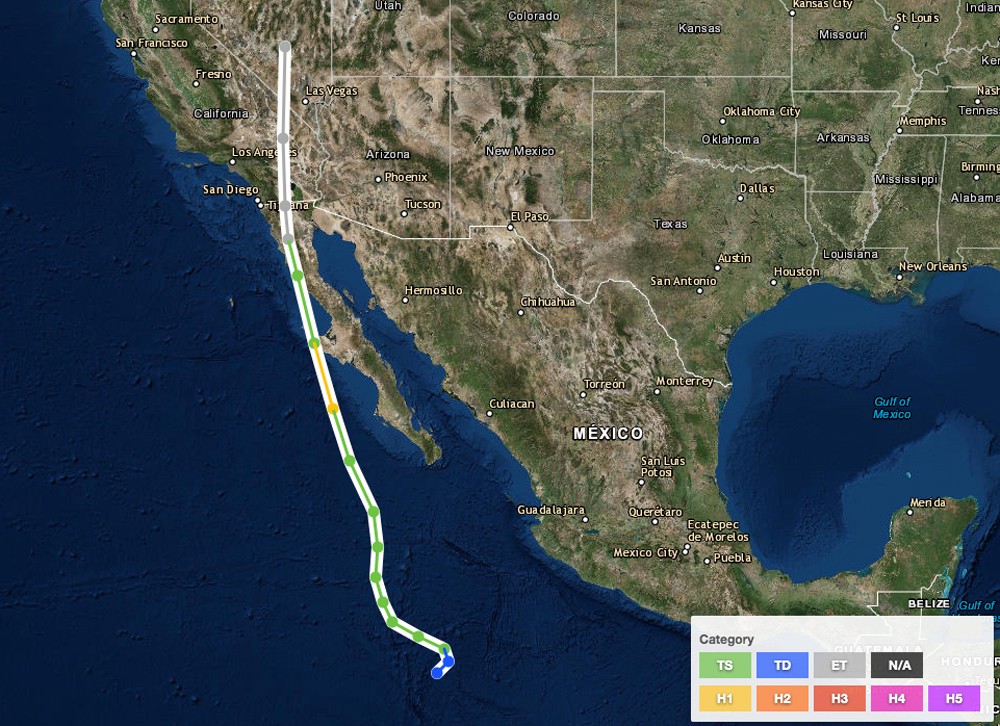 Kathleen in 1976 was only briefly a Category 1 hurricane (yellow) but the path and rainfall totals show what?s possible when a tropical system barrels northward. Green represents Tropical Storm status, and gray is extratropical. Source: NOAA
Linda, in September 1997, was the strongest eastern Pacific hurricane on record at the time, with Category 5 winds of 185 mph at one point. For a time, the National Hurricane Center actually warned Southern California residents they might be a target. The storm veered out to sea, but still brought rain and 18-foot waves that caused millions of dollars in damage to the state.
?Every year we plan for the possibility that a hurricane could strike San Diego or Los Angeles,? Landsea says. ?On the preparedness side, we?re ready for a hurricane to hit there. Whether or not the population is ready or not is another thing.?
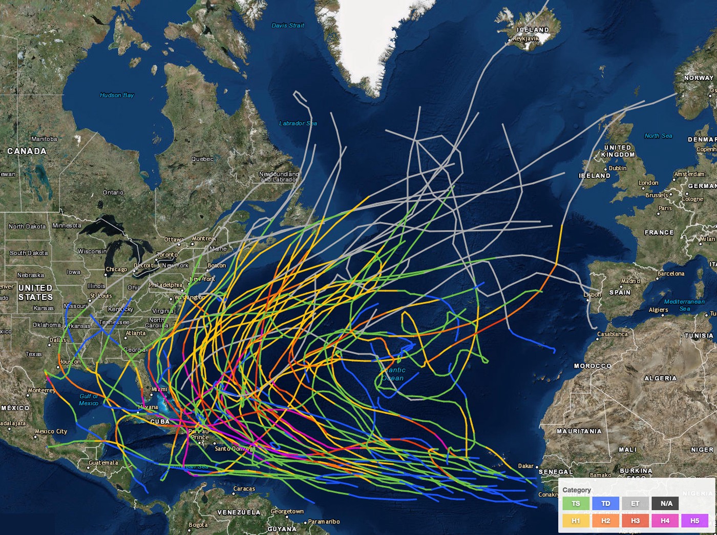 Paths of Atlantic Ocean hurricanes from 2008 to 2017. Source: NOAA
Similarly, Pacific hurricanes are often ushered westward, away from the Americas. But if conditions allow a hurricane in the eastern Pacific to move northward, it can get caught up in easterly winds and, as happens now and then, be pushed into Mexico or Baja California.
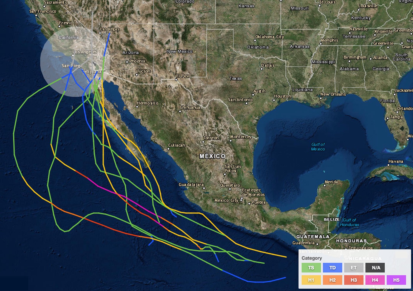
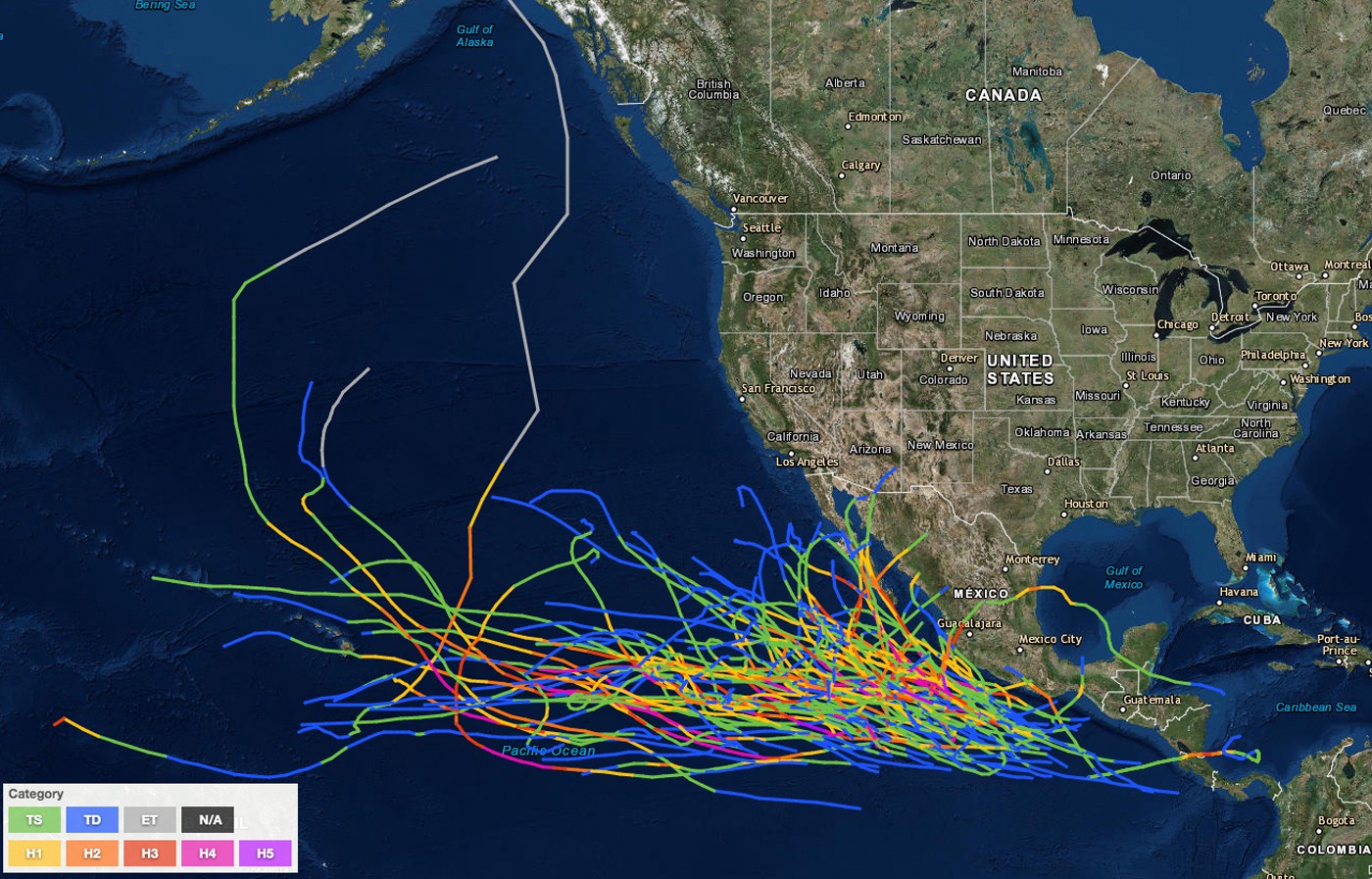 Paths of Eastern North Pacific hurricanes from 2008 to 2017. Source: NOAA
For a tropical storm to become a hurricane and thrive, it needs warm water (80 degrees Fahrenheit or higher). As tropical systems move northward (along either coast) they encounter cooler seas and, in lay terms, lose steam. Now, look at the dramatic difference in average sea surface temperatures in early August off the coasts of these two cities, one of which is notably more hurricane-prone:
- Miami Beach: 86 degrees Fahrenheit
- Los Angeles: 68 degrees Fahrenheit
Those are averages. The actual temperatures can vary greatly. In fact, last year, the Pacific Ocean off Southern California was unusually warm in early August, with an 80-degree reading reported by the National Weather Service off Solana Beach, north of San Diego, and 78.6 degrees off the coast of La Jolla.
A storm might retain minimal hurricane status for a short period while racing over 78.6-degree water, but it?ll lose steam quickly. And there are other limiting factors involved. So to cook up a landfalling California hurricane, you need to get the ingredients just right.
First, you almost surely need an El Nio, the periodic warming of water in the eastern Pacific. It?s a strong El Nio that brings the bathtub water to the Beach Boys? stomping grounds. (The current El Nio has a 70% chance of staying in place through summer and a 55?60% chance of lingering into fall, according to NOAA?s latest outlook, June 3.)
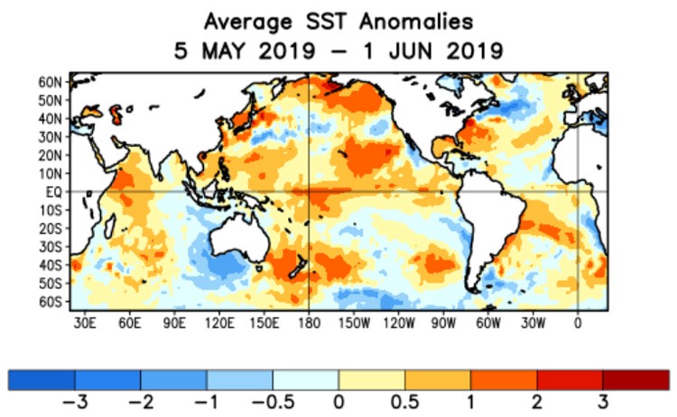 Sea surface temperature departures from normal during a recent four-week period show above average conditions in the equatorial Pacific, particularly off the coast of Baja California. Image: NOAA
The cycle of El Nio and its cooler sister La Nia has a significant effect in the air, too. During El Nio, energy is pushed high into the atmosphere and traverses the United States like a river. It continues on out into the Atlantic Ocean, having a tremendous impact on hurricanes in the Atlantic basin, which includes the Caribbean and the Gulf of Mexico. Here?s why.
In a tropical system, warm, moist air rushes inward at the surface, rising up in bands of thunderstorms. Near the center, the air rises the highest, and it flows outward much like smoke from a chimney. The high-altitude, energetic winds of El Nio create a shear that tends to rip these chimneys apart, throttling hurricane formation. In strong El Nio years, there are on average fewer Atlantic basin hurricanes, and fewer very strong ones.
El Nio has the opposite effect in the Pacific, Landsea explains.
?With warmer water, there is typically less wind shear, which allows a hurricane to stay stronger farther north,? he says. The wind shear is always there. The difference is typically more than 25 mph between winds a mile above the ocean and winds eight miles up. ?Stronger than a 25 mph difference disrupts hurricanes and makes them fall apart.?
But for a few days in any year, especially in an El Nio year, the shear in the eastern Pacific can drop below the 25 mph threshold, allowing any hurricane that might come along to stay intact.
?That combination is really rare,? Landsea stresses. ?Even in an El Nio year, usually the atmosphere is not going to support a hurricane coming through there. But when San Diego or Los Angeles gets its next hurricane, it will likely be in an El Nio year.?
For the record, the chances of a hurricane striking north of L.A. are ?near zero,? he says.
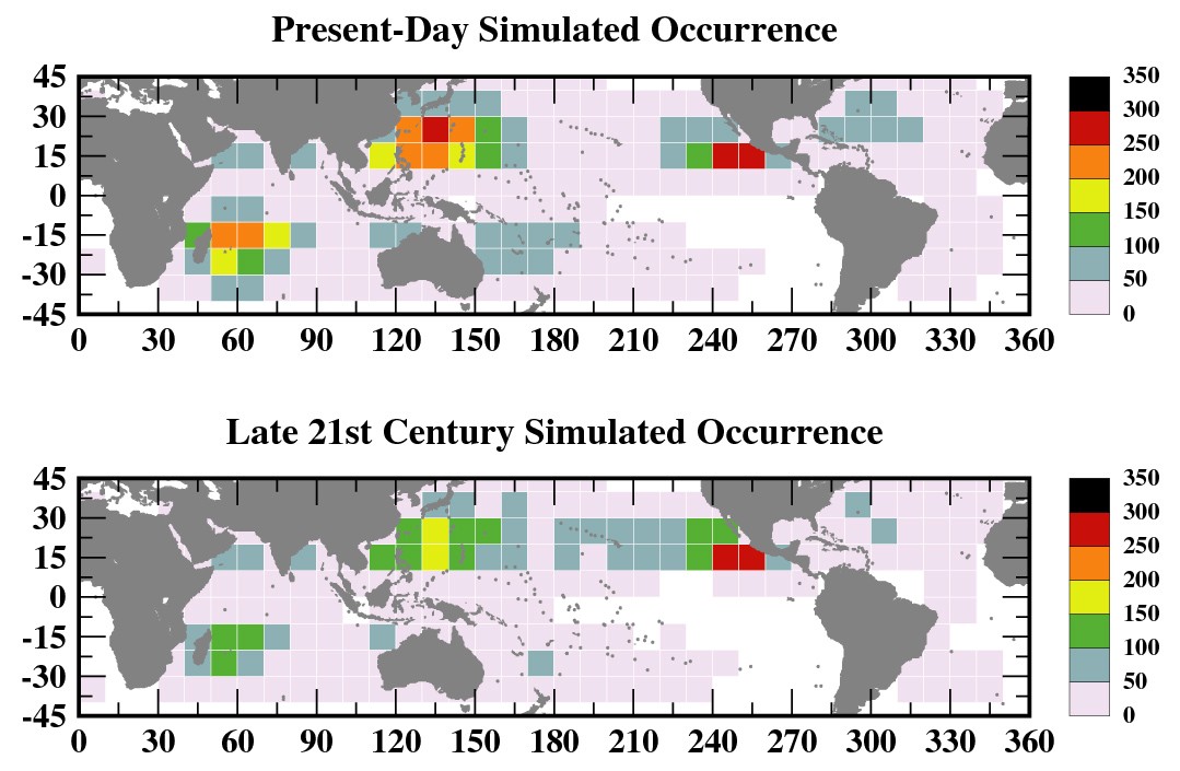 The number of hurricane-days per 20 years in various locations now (top) and late this century given global-warming projections. Graphic: NOAA
When the seemingly inevitable arrives in California, wind won?t be the biggest worry, Landsea says. For one thing, any storm that makes landfall there as a hurricane will be a Category 1 or Category 2 at most, with top sustained winds no more than 110 mph. Unlike in 1858, most structures in Southern California nowadays are built to withstand earthquakes and would likely fare pretty well in the face of such winds.
Storm surge, a big worry with many hurricanes, will have less impact in Southern California. A Category 1 or 2 hurricane?s storm surge would be on the order of five to 10 feet, Landsea says, but because the elevation rises rapidly near most beaches, the surge wouldn?t travel far, as it often can along the low-lying Gulf Coast or East Coast.
?The big issue will be the rain,? Landsea says. As in 10 to 20 inches, which would cause ?catastrophic flooding,? he says. (The average annual rainfall in Los Angeles is 15 inches.)
And here?s a twist: Tropical systems don?t pay much attention to what we call them. Even if a big, wet, slow-moving hurricane degrades into a mere tropical storm before hitting San Diego or L.A., it can bring as much rain as it would have as a hurricane.
So what are the odds a hurricane will strike California this year, or any year?
In a 2012 interview, oceanographer and climatologist Bill Patzert, one of the few other scientists to even address the topic of a California hurricane, put it this way: ?The odds are infinitesimal ? so small that everyone should just relax,? he said. ?Like 1-in-1,000. Of course, there?s always a chance.? And like Landsea, Patzert said conditions would have to be perfect. ?The best odds for a tropical cyclone to affect Southern California are during a ?Godzilla? El Nio event, when the waters off the coast are warmest, like we had in 1997?98,? he said.
On the assumption Patzert?s odds were off the cuff, I asked Landsea if he?d venture to pin the chances down.
?It?s difficult to put odds on it,? he said, given that it?s happened just once in modern times, ?but it?s on the order of 1-in-100 to 1-in-1000.?
The seasonal hurricane forecast for 2019 calls for a near normal year in the Atlantic basin, and above normal activity in the Pacific ? exactly what you?d expect in an El Nio year. But rest easy, Californians, and continue to focus your worry on Mother Nature?s other threats. But on warm October days, when the ocean feels like a bathtub, maybe keep half an eye on the horizon.
