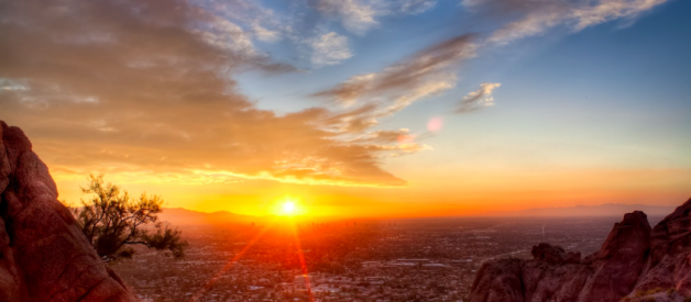
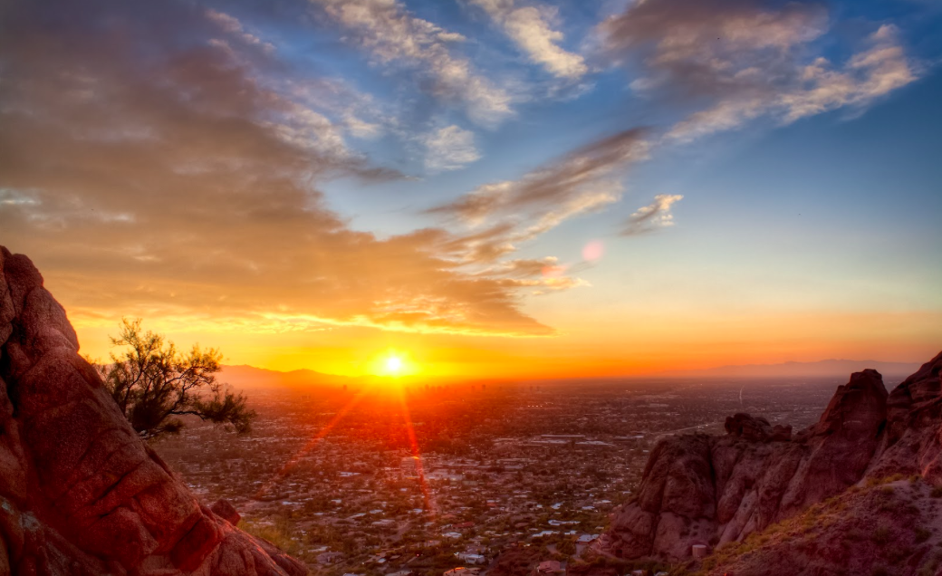
Phoenix, America?s sunniest metropolis and the cosmopolitan heart of Arizona, basks in sunshine all year long. With gorgeous red rocks, blue skies and bright sun-rays, the dry weather makes this a great area to run. A ?must do? in Phoenix is to plan a run amid the rocks during sunrise or sunset, to enjoy the spectacular light. Also, desert wildflowers in spring or just after a rain can be a special treat.
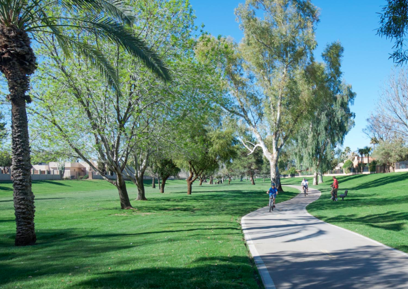
Phoenix is one of the fastest-growing cities in the U.S. It is spread out and auto-centric. Running options in the heart of downtown are not great. The best options are in North Phoenix: Murphy?s Bridle Path, and the canal trails. If you have the option, we?d recommend staying in downtown Tempe rather than downtown Phoenix. It?s the same distance from the airport as downtown Phoenix, and has some great running options right downtown, including the Town Lake trail, and proximity to the Desert Botanical Garden and Papago Park. Nearby Scottsdale has a beautiful greenbelt popular with runners, and access to the Camelback Mountain area. Also, Phoenix and Tempe are now connected by a terrific light rail system, which runs downtown to downtown every 20 minutes or so and only takes 20 minutes.
The running experience in Phoenix is not complete without doing some of the off-road mountain trails. The Camelback area is among the easiest to access and most popular.
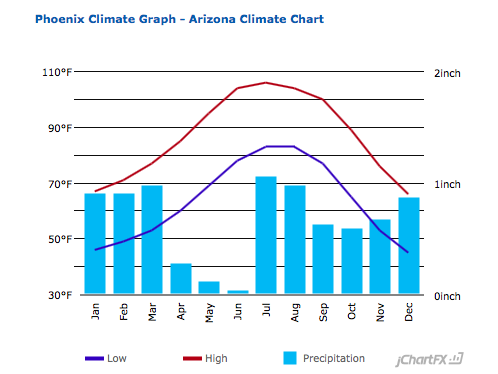
Phoenix is in the desert. Which means it can be brutally hot. In summer, temps reach 120F and don?t even dip below 80F at night, so hydrating and wearing sun block are critically important. The weather?s great from November-April, but desert mornings can be chilly. Some running groups go early in the morning in summer. Topographically, the city itself is flat but is surrounded by mountains, affording some amazing trail running opportunities.
The Iconic Routes
- Papago Park
- Arizona Grand Canal Trail
- Murphy Bridle Path
- Tempe Town Lake
- Indian Wash Greenbelt
The Routes
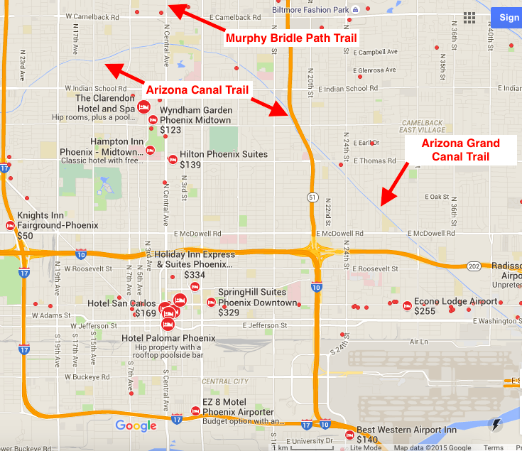
Arizona Canal Trail
35.9 miles total ? MAPMultiple distances
The Arizona Canal Trail is one of the longer multi-use trails in Maricopa County, running between Phoenix and Peoria along both sides of the Arizona Canal. The closest access point to downtown Phoenix is ~9 miles north. The trail connects to a number of other trails along its route, including the New River Trail, the Cave Creek Trail, and the Skunk Creek Trail. This trail is one of the most trafficked for running and will also include many cyclists, as there are numerous underpaths and very little auto traffic to deal with. Note: there are no street lights on this trail if running at night.
Arizona Grand Canal Trail
21 miles ? MAPMultiple distances
The Grand Canal, the oldest remaining pioneer canal on the north side of the Salt River, runs 21 miles east-west from 75th Avenue and Camelback Road all the way to Papago Park. The path is paved in most areas, though in some areas it?s a hard-packed dirt path. This is also a great place to see birds of the area as they are frequently seen along the route. You will also see some beautiful homes along the way, including the Wrigley mansion and the Biltmore. The closest access to downtown Phoenix is 4 miles north up 15th St.
Papago Park
5.6 mile LOOP, with several more options. Start: multiple points. MAPPapago Park is a hilly desert park covering 1500 acres in Phoenix and Tempe. It?s a great spot for running, featuring a combination of paved and non-paved trails, moderately hilly. There are several interesting sights, including Hole in the Rock, the Desert Botanical Garden, several small lakes, and the Phoenix Zoo. There are numerous trail and loop options. Here is a LINK that describes several routes. It?s ~2.5 miles N-S and ~1 mile E-W. The park trails can be combined with runs Arizona State University and the Tempe Town Lake Trails.
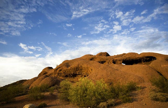
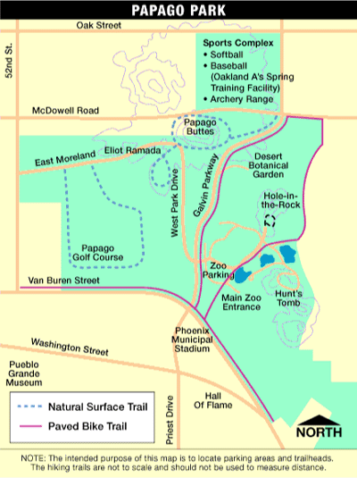 Photo source: Visitphoenix.com
Downtown Phoenix
4.25 miles. Start: Heritage Square, 7th & Van Buren. MAP
Downtown Phoenix is not much for running. But if you?re staying downtown and pressed for time, there are a couple of options. Central City, only 4 miles from the airport, is bound by I-10 & I-17. A good ?tour of downtown? would run mainly west of 7th St., toward the State Capitol, using Van Buren, Monroe, or Adams. Sites include Heritage Square, Arizona Science Center Children?s Museum, Convention Center, Chase Field (baseball), Herberger Theater for Performing Arts, the Orpheum Theater, basketball arena, a couple of parks, and the Capitol. There are lots of hotels in this area too. Other areas/streets within downtown for running include **.
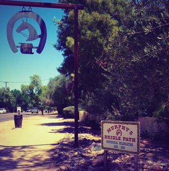
Murphy?s Bridle Path
aka Central Ave Hiking Trail2.65 miles ONE WAY ? MAP
Just 5 miles north of downtown in North Phoenix, Murphy?s Bridle Path offers a pleasant, relatively shaded dirt running trail. Originally a horse trail, the path follows Central Avenue, a 2 square mile area originally developed in the late 1800s as an upscale Phoenix suburb. Some of Phoenix?s most historic homes are in this area. Olive and ash trees were added along both sides of Central Avenue with citrus trees from Southern California planted on the interior portions to make the area more attractive to new investors and homeowners. The path runs 2.6 miles one-way, so this is a nice 5-ish mile there and back. Vary the run or add to it by enjoying some of the additional residential streets in the area. If you are not close enough to walk (or run) to this path, parking is available in the North Phoenix Baptist Church lot at Central Ave. and Bethany Home road. Like the Arizonal Canal Trail, this path is not lit so take into consideration the time of day of your run.
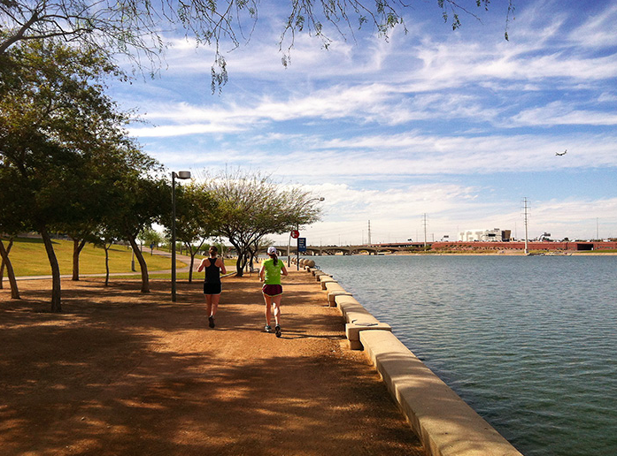
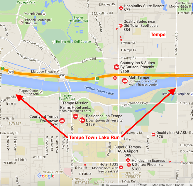
Tempe Town Lake
3.5 miles ONE-WAY ? MAP7.5 mile loop ? MAP
Tempe is a the same distance from the Phoenix airport as downtown Phoenix, and offers some great options for running. Tempe Town Lake, in the heart of downtown and adjacent to the University of Arizona campus, has a wonderful running trail along each side. Quiet, peaceful and a nice change of scenery are all great ways to describe what you will experience here along this narrow, man-made lake. You can run a 3.5 mile stretch along the lake, or make a complete loop for 7.5 miles. On the south (Tempe) side, are downtown Tempe, Beach Park, and the University of Arizona campus. On the north side, there?s access to Papago Park and its wonderful trail options.
Arizona State University/A Mountain
4.6 miles RT. Hilly. Start: Palm Way at Intramural fields. MAP
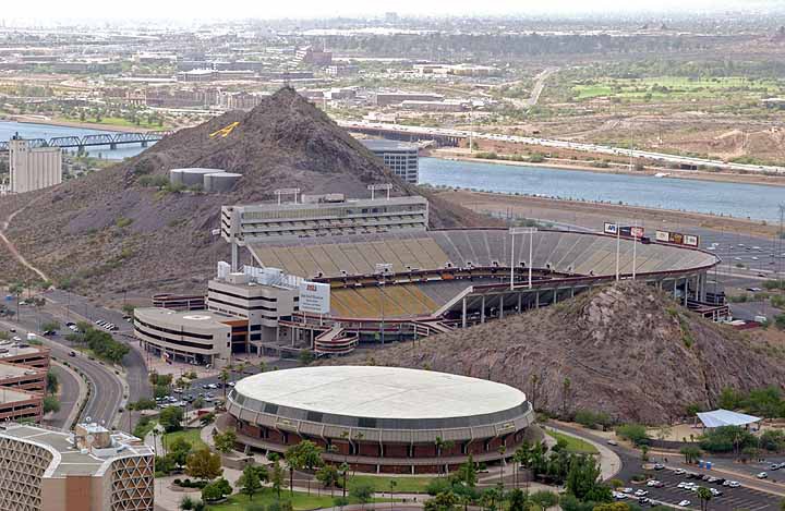
The campus of 50,000 student Arizona State University defines Tempe. It?s adjacent to the downtown and Lake trail areas. It?s a great run through the campus, featuring palm-lined pedestrian malls, subtropical vegetation, and interesting architecture. A highlight of the run is the short but very steep run/walk to the top of ?A Mountain?. Our loop combines the nicer paths within the university, the mountain, and a brief stretch along the Tempe Lake Trail. It?s possible to do more within the campus ? there are lots of nice pedestrian malls, or to add on by running a bit in downtown Tempe or more along the lake trail.
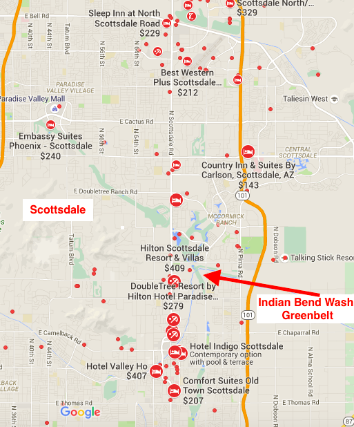
Indian Bend Wash Greenbelt
11 miles ? MAP Multiple distances
The Indian Bend Wash Greenbelt is an oasis of parks, lakes, paths and golf courses traversing 11 miles through the heart of Scottsdale. The greenbelt features more than 24 grade-separated crossings, meaning runners can avoid major cross traffic. The trail connects on the north end to the Pima Road Trail and the Indian Bend Rd. to Shea Blvd. Trail. On the south end, the greenbelt runs into downtown Tempe, and the Tempe Lake trails.
Further Afield
Trail running is very popular in Phoenix but it requires getting out of the city. If you have a car and the time, the following runs are a ?most do.?
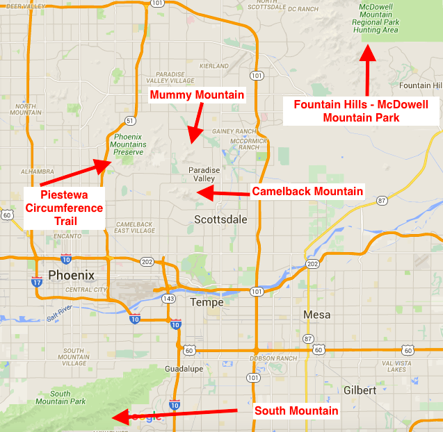
Camelback Mountain
-Echo Canyon Summit Trail-Cholla TrailMAPCamelback Mountain is iconic throughout the Phoenix area, and is one of the best places to get a good workout. Extreme heat, no shade, elevation gain? and crowds can make this a challenging run, but the view of the Phoenix metro area is spectacular. It?s a little over a mile to the summit from either the east or west trailhead, or 4.3mi point-to-point. Access is about 4 miles from downtown Scottsdale, or right there if you?re staying at the Phonecian Resort or the JW Marriott. TRAIL MAP
McDowell Mountain Regional Park
MAP. MORE INFO.A 30 minute drive from Scottsdale. This is a popular desert park, 21,000 acres, with many trails used for hiking, mountain biking, and running.
South Mountain
List of trails & MAP
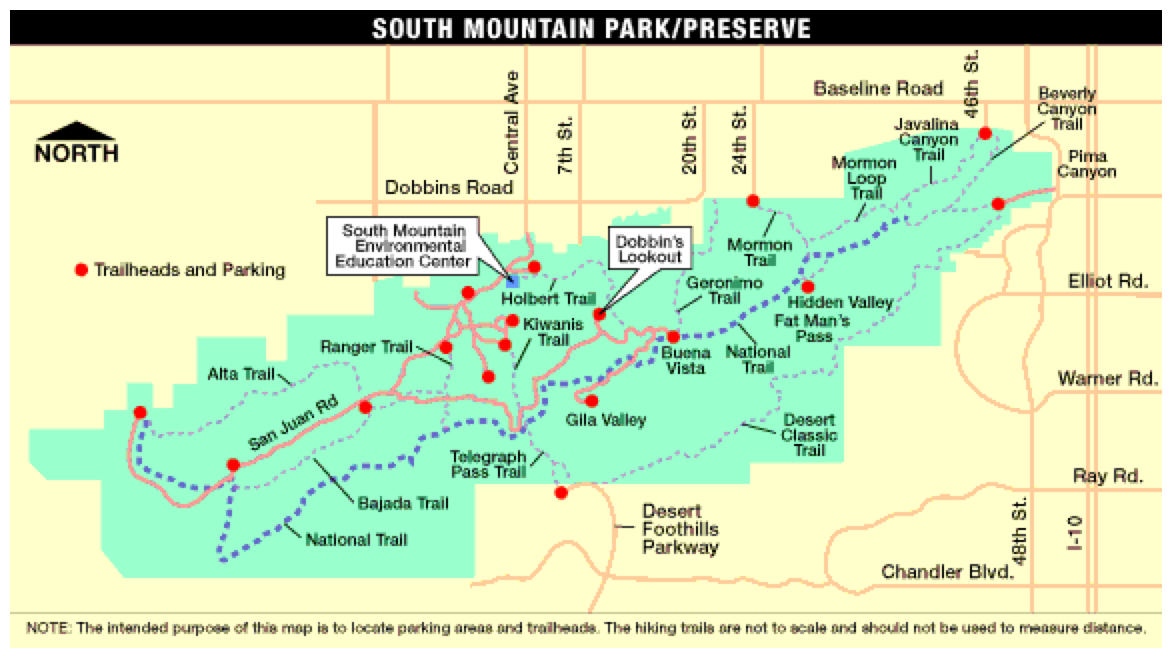
This fabulous park is 8 miles south of downtown Phoenix. Covering 16,000 acres, South Mountain Park features a great variety of trail running options. Our link here is to the park site, with info about the trails.
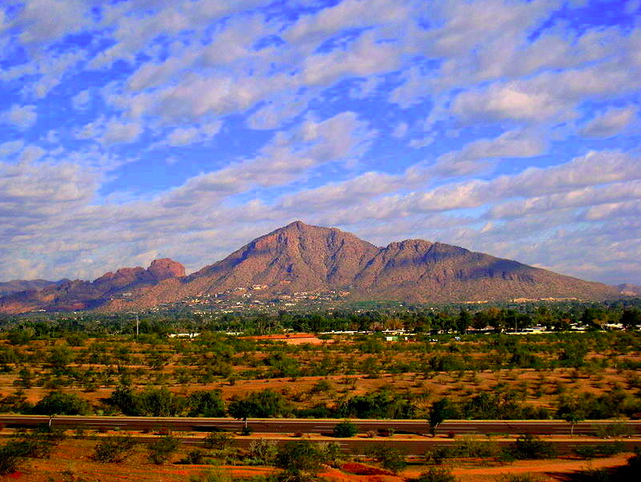
Mummy Mountain
MAPNot far from Camelback Mountain, Mummy Mountain has great views and very little traffic to interrupt your run. With wide streets, large houses and a view of the whole valley, this a great place to run.
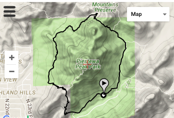
Piestewa Circumference Trail
Piestewa Peak Park, 11 miles north of Phoenix and 8 miles east of Scottsdale, is one of the best secrets in the area for its solitude and gorgeous scenery. The ~4 mile ?Freedom Trail? around the circumference of the peak, is a great and not overly strenuous desert trail running choice.
Stay
Phoenix has no shortage of hotels and most travelers stay in Central Phoenix (aka Downtown), Scottsdale or Tempe to stay close to the action. We recommend staying in downtown Tempe rather than downtown Phoenix for more interesting and easily accessible running options.
Central Phoenix ? Downtown
Bordered by Thomas Road on the north, Buckeye Road to the south and bookended by Seventh and 19th streets, downtown is Phoenix?s historic and cultural hub, with 19th-century Historic Heritage Square at its center. Here you are close to restaurants, shops and museums. Mass transit links downtown with Sky Harbor International Airport,Scottsdale and Tempe.
Scottsdale
Twenty- five minutes northwest of downtown Phoenix, Scottsdale is where to stay in Phoenix if you?re looking to rub shoulders with the well-heeled. Old Town Scottsdale has bustling cafs by day and a buzzing night life. Try staying within some proximity of the Greenbelt for good running options. Also the Phoenician and JW Marriott Scottsdale are at the foot of Camelback Mtn.
Tempe
Laid-back Tempe, 25 minutes southwest of downtown Phoenix and below Scottsdale, is easily accessible from downtown Phoenix via the Valley Metro Light Rail. There are great running options accessible from downtown Tempe: the lake trail, Papago Park, and the southern end of the Scottsdale greenbelt.
Running Stores/Group Runs
Runner?s DenAs Arizona?s original running specialist, Runner?s Den has been a pillar of the Arizona running community since its doors opened in 1978. Votedne of America?s ?Top Ten? running stores. Group runs: Wednesday at 6pm (a scenic out-and-back along the Arizona Canal and through the Biltmore), Saturday morning at 6am, and every other Thursday at 6pm for a trail run starting at Dreamy Draw Park.
Sole Sports Running ZoneWith 3 stores in the Phoenix area, owned by professional triathlete Lance Muzlay. Group runs:Glendale: Wednesday 6:30pm/Saturday 6:00am summer/7:00am winter.Scottsdale: Tuesday & Thursday 6:30pm/Saturday 6:00am/7:00am winter.Tempe: Monday & Thursday 6:30pm/Saturday 6:00am/7:00am winter.
iRun Running StoreFull service running, walking, and hiking shop located in the beautiful Arcadia near Scottsdale. Reviewed as the best running store in Phoenix, especially for trail running. Group runs: 5 mile group runs Thursday at 5:30pm (Happy Hour 5 Mile Run) and Saturday at 6:00am.
Other group runs
Aravaipa RunningA very popular running group (read-large turnout) with numerous events and weekly group runs. Dedicated to creating a vibrant community centered around being outdoors.
Meet Me DowntownMeet Me Downtown (MMDT) connects people of all ages to downtown Phoenix for a weekly social walk/run.
Arizona Road RacersWith over 1200 members, Arizona Road Racers (ARR) is the largest and oldest running club in Arizona and is one of the largest of such clubs in the USA. They are well organized, do races all year long, and host fun and affordable events.
Events
Due to the extreme heat in the summer, most running events in Phoenix are held fall through spring.
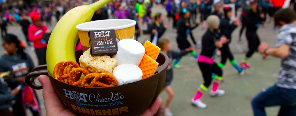
Hot Chocolate (yes, really) December. 5K, 15KHeld in Scottsdale, this race is a chocolate lovers dream ? marshmallow sweet stations dotted along the course with a fondue station at the end, not to mention a Finishers Mug filled with goodies.
Midnight Madness December 31st. 5KEnd one year and begin another with this New Year?s Eve 5K. Fun, festivities and sparkling cider toasted at midnight.
Rock N? Roll Arizona January. 5K, 10K, half marathon, marathon. This course is flat and fast with epic views of the valley of the sun, including Papago Park and Tempe town lake. Participants will enjoy live bands, cheer teams, spirited water stations and other entertainment along the course.

Runner?s Den Pancake Run February. 5K, 10K 15KLimited to only 2,000 runners, this 5K, 10K or ?Double Stack? 15K race is sponsored by IHOP with a complimentary pancake breakfast. Originally staged in 1979 to showcase the talents of marathon legend Bill Rodgers and the opening of Paradise Valley Mall, the event remains a Valley classic.
Pat?s Run April 4.2 milesPat?s Run is the signature fundraising event of the Pat Tillman Foundation, held to commemorate the day Pat lost his life in Afghanistan serving with the 75th Ranger Regiment, Pat?s Run is a 4.2 Mile Run/Walk that winds through the streets of Tempe to Sun Devil Stadium, ending at the 42-yard line of Frank Kush Field, symbolic of the #42 jersey Pat wore as an ASU Sun Devil.

