Subway NY NJ is a proposal to return New Jersey to the New York City Subway Map and prominently display PATH lines, for a more complete map of rapid transit in the urban core of New York.
New York has Two Subways
New York City Subway, operated by the Metropolitan Transportation Authority (MTA), is the seventh busiest rapid transit rail system in the world, and the busiest in the US, with over 1.7 billion riders in 2012. Including the Staten Island Railway, the system provides service 24 hours a day, every day, in all five boroughs of New York City.
Port Authority Trans-Hudson (PATH), operated by the Port Authority of New York and New Jersey (PANYNJ), connects the New York City borough of Manhattan with the northern New Jersey municipalities of Harrison, Hoboken, Jersey City, and Newark, and carried 72.6 million riders in 2012, more than the entire public transit systems in Atlanta, Los Angeles, or Miami.
The Subway Map Today
The current New York City Subway Map shows the PATH tracks and stations in Manhattan, but there are several deficiencies with the current display.
- PATH is Incorrectly Represented ? PATH is a rapid-transit system. It operates 24/7, provides frequent service with short headways (time between trains), accepts the same pay-per-ride MetroCard as the Subway for fare payment, and has six underground stations in Manhattan (four with direct physical connections to the New York City Subway). The current fleet of PATH train cars (PA5) are an updated version of the Subway cars (R142A) used on the 4 and 6 trains. However, PATH is represented on the Subway Map using the visual style labeled ?Commuter rail service? in the map?s key: pale blue ?railroad track? lines, square station markers, and small, lightweight text labels. This appears to be an incorrect application of the MTA visual style guide, and doesn?t effectively communicate to Subway riders that PATH is also a rapid-transit service.
- Hudson Waterfront is Missing ? PATH connects New York and New Jersey, but the Hudson Waterfront and stations across the river from Manhattan are missing from the current Subway Map, so Subway riders who want to connect to PATH to reach destinations in New Jersey currently see no information about where PATH can take them.
Proposed: A More Complete Map, Displayed on Both Systems
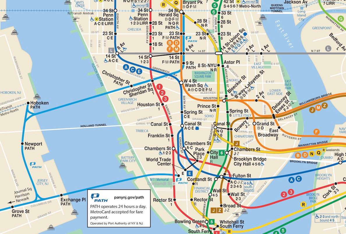
1. Display PATH as a Rapid Transit Service ? Show PATH lines using a solid line rendered in the light blue color used for the PATH logo. Include PATH logo to identify the line. Replace current blue squares representing World Trade Center, Christopher St, 9th St, 14th St, 23rd St, and 33rd St stations with circles and labels that match the visual style of New York City Subway stations. PATH trains make all station stops, so black circles should be used to indicate local service. In Subway Map Key, add PATH logo and the following information: ?Port Authority Trans-Hudson (PATH) service is operated by the Port Authority of NY & NJ. PATH accepts the Pay-Per-Ride MetroCard for fare payment; Unlimited Ride and EasyPayXpress MetroCards are not accepted on PATH: Visit panynj.gov/path for more information.?
2. Include Hudson Waterfront and Stations ? There is room within the current boundaries of the Subway Map to include the Hudson Waterfront and four of the seven PATH stations in New Jersey. Add geographical representation of Hudson Waterfront to left edge of map, and include labels for Jersey City and Hoboken, waterfront cities with PATH stations. Add black circles and labels to represent stations at Exchange Place, Grove Street, Hoboken, and Newport. Add an arrow to indicate that service continues off map to Journal Square, Harrison, and Newark.
3. Display Updated Subway Map on Both Systems
The updated map should be displayed on all PATH Trains in addition to all New York City Subway trains. Each New York City Subway car typically contains eight 22? X 21? advertising spaces called Subway Squares ? two of which are used to display the Subway Map at either end of every car. The equivalent in PATH cars is the Commuter Card ? a 33? x 21? advertising space adjacent to the doors in each car.
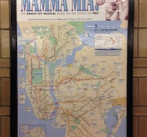
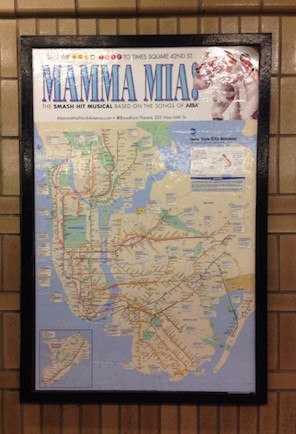
The height difference between the two cards presents an advertising opportunity for PATH: an 11? x 21? strip at the top or bottom of the map that would allow advertisers to reach riders every time they look at the map to plan the next stage of their journey. A similar type of advertising (pictured) is visible in several New York City Subway stations near the theater where Mamma Mia plays.
Note: This proposal does not suggest replacing existing PATH line maps, currently displayed above the doors throughout PATH trains. Those maps display the full PATH system, whereas this proposal only displays PATH stations that fit within the existing boundaries of the Subway Map: all six stations in New York, and four of the seven stations in New Jersey. The two maps would serve different and complementary purposes: line maps put stations in the context of the full PATH system, and the Subway NY NJ map would serve as a wayfinding tool to put PATH in the context of Subway service throughout New York City.
Why change the New York City Subway Map?
Transit maps like the New York City Subway Map are more than just way-finding tools; they become cultural assets that frame how people see the city. Over 5 million people ride the subway on weekdays, and New York City received over 58 million visitors in 2012, which means the Subway Map is one of the most widely recognized public transit maps in the world. Besides appearing on Subway trains and in stations, the map is featured in apps, clothing, home furnishings, souvenirs, sporting goods, toys, works of art, and derivative works, like this Super Mario-themed design.
Including PATH on the Subway Map in a manner that better reflects its role as New York?s ?second subway? improves knowledge of cross-Hudson rapid transit among the largest audience of transit riders in the New York area, supports greater transit use and economic activity on both sides of the Hudson, and acknowledges the economic, cultural, and geographic ties between Manhattan and the area of Hudson County that has been described as New York City?s ?sixth borough?.
Historically, geographically, and commercially New York and the industrial district in the northern part of the state of New Jersey constitute a single community. ? Interstate Commerce Commission, 1917
For the MTA and Port Authority, it would serve as another example of smart inter-agency cooperation that directly benefits the transit-riding public. The Subway Map already displays AirTrain JFK, which is operated by the Port Authority, using a visual style consistent with the rest of the Subway Map. This kind of cooperation for the public benefit is seen in other cities, too. For example, the Philadelphia Rail Transit Map shows rapid transit services provided by two agencies: Southeastern Pennsylvania Transportation Authority (SEPTA), which operates most lines, and Delaware River Port Authority, which operates the PATCO Line connecting Philadelphia with Camden and several other points in New Jersey. The SEPTA map key includes the disclaimer ?not a SEPTA service? next to the PATCO Line, but represents the line using a visual style consistent with all other rapid transit lines in Philadelphia.
Subway maps in New York City have a long history of including the Hudson Waterfront and subway connections between New York and New Jersey. After the IRT, BMT, and Independent Subway System (IND) were consolidated into a single system, the 1948 Hagstrom map included the Jersey City waterfront, H&M lines labeled ?Hudson Tubes (to Newark)?, stations in Manhattan, and Exchange Place station in New Jersey.
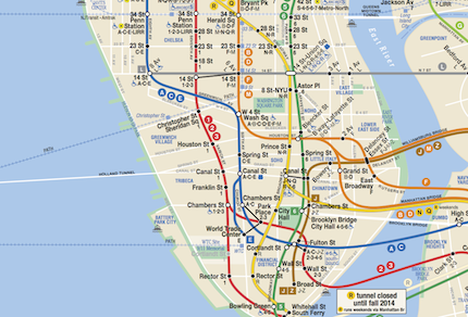
The 1968 map (pictured) displayed the H&M tunnels (labeled ?PATH Tubes?), and stations (represented with black dots) more prominently than previous maps, but did not include labels containing station names. It also included an unlabeled outline of the Hudson Waterfront.
The Hudson Waterfront and PATH were excluded from the 1972 map designed by Massimo Vignelli. A small portion of the Hudson Waterfront, labeled ?New Jersey? reappeared on the 1979 map, but has been absent since about 1990. Bringing it back, and improving how PATH is represented, will give 1.8 billion annual transit riders a more complete picture of rapid-transit service in the urban core of New York and New Jersey.
About the Author
Subway NY NJ was created by Stewart Mader, a frequent Subway and PATH rider, and advocate for good urban planning and transit.
Originally published at subwaynynj.com on August 5, 2015.

